| PACKAGE INCLUDES |
|
| TREKKING PACKAGE INCLUDES |
|
| PACKAGE EXCLUDES |
|
Paro Rinpung Dzong
Rinpung Dzong or the "fortress on a heap of jewel" was built by Zhabdrung Ngawang
Namgyel in 1646. Its majestically on a hill overseeing the Pa chhu(river) and offers a
panoramic view of Paro valley.
Taa Dzong
Taa Dzong or watch tower was built in 1645 by Paro penlop La Ngoenpa Tenzin Drukda
together with Desi Minjur Tempa. It was built to protect the Dzong(fortress) and the
valley from unceasing attacks from outside. The watchtower was converted to a national
museum in 1967. The museum has an exhibit several antiques and relics of Bhutan, they
also exhibits the natural history and cultural practices.
Taksang Monastery - Acclimatizing Hike
Your highlight of the tour and a day excursion to one of the most petrified sites in
Bhutan, Taktsang Monastery / Tiger`s Nest which is about 3 hours uphill and 2 hours
down. It is located around 900 meters above the Paro valley. In the 8th Century Guru
Padmasambhava - the patron saint of Buddhism established the most sacred place in Bhutan
and meditated with his consort Khandro Yeshey Tshogyal. It is believed that Guru flew on
a female tigress in pursuit of a demon which he subdued at the current site of the
Monastery. You can have your lunch, tea/snacks at the cafeteria midway.
Sharna Zampa - Thangthangkha
Walking Distance: 22 km, 7-8 hours, 770 m ascent, 10 m descent, camp altitude
3,610m
Brace yourself for a long, hard day with lots of ups and downs, made worse by all the
rock-hopping required to avoid mud holes. Begin the day by climbing through conifers and
rhododendrons flanking the Paro chhu. You might have to scramble over small hills to get
around the river in places. Your campsite will be at thangthangka (3,610m), with a small
stone shelter and a Bhutanese-style house in a cedar grove at the edge of the meadow.
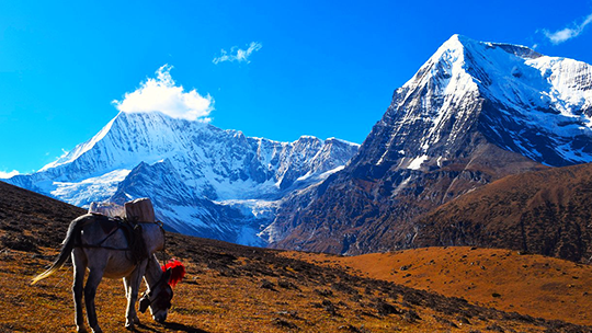
Thangthangkha - Jangothang
Walking Distance: 19 km, 5-6 hours, 480 m ascent, camp altitude 4,080m
If you did not see Mount Jomolhari the previous evening, you will get a great view in
the morning. The trek continues up the Paro Chhu river valley which widens into patches
of alpine meadow and scanty growths of forest. Cross an army outpost along the way and
enjoy a spectacular view of high mountain ridges and snow-capped peaks. Yaks and the
herder`s homes become a regular feature of the landscape. Passing the beautiful villages
Soe, Takethang and Dangochang is another highlight of today. Reaching Jangothang, one of
the most beautiful campsites of the Himalayas, you will again have a spectacular view of
Mount Jomolhari.
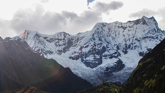
Acclimatization
Camp Altitude: 4,080m
Jangothang is a perfect environment for your acclimatization. There are plenty of
possibilities for day hikes with great views on lakes and snow capped mountains such as
Jomolhari and Jichu Drake. Jichu Drake is also one of those unclimbed mountains. There
are good chances to spot some blue sheep on the upper slopes of the valley. There are
good short hiking trails in three directions. Jumolhari and its subsidiary mountain
chains lies directly west, Jichu Drake to the north and a number of unclimbed peaks to
the east. Nearby there are trout filled lakes. You may also walk towards the glaciers of
Jhomolhari or visit and experience a high altitude village life nearby. Don`t sweat it
too much as you prepare yourself for a tough climb the next day.
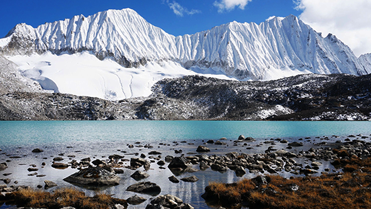
Jangothang - Soi Yaksa
Walking Distance: 16km, 6-7 hours, 810m ascent, 1,090m descent, camp altitude
3,800m
From Jangothang, the return trail initially leads northto the last settlement in valley,
before dropping to paro chhu, crossing it on a wooden bridge. After crossing the river,
you begin a gradual climb, following a set of sharp switchbacks for about 300m up the
side of the hill. Along the way, you can get fabulous view of mount. Jhomolhari,
Jichudrakey and Tserim Kang if the weather is good. Its relatively even and smooth hike
all the way to a large cirque nestling the lake of Tshophu(4380m), a pair of splendid
high-altitude water bodies inhabited by a flock of ruddy shelducks and known to foster a
healthy population of brown trout deep in their placid water. While its possible to set
up camp in between two lakes,you could always carry on along the trail, which now climd
high above the eastern side of the first lake, passes the second lake along the wayand
finally climds across a scree slope to the crest of ridge. From here, it descents into a
hidden valley, before climbing steeply to Bhonte La(4890m), the highest point on this
route.
Descending from Bhonte la, the route now runpass a scree slope, and then winds down a
ridge with lot of criss-crossing yak trails. Finally it switchback down to Soi Yaksa
valley (also known as Dhumzo chhu valley), a beautiful setting for a camp at 3800m with
rocky cliff, wild-flower meadows, a few nomadic settlements and a waterfall at the end
of the valley. All through this days, keep your eyes trained on wilderness for a host of
regional wildlife, such as blue sheep, golden marmots and the elusive snow leopard.
Soi Yaksa - Thombu Shong
Walking Distance: 11km, 4-5 hours, 720m ascent, 340m descent, camp altitude
4,180m
Starting out from camp, todays walk initially takes you pass hillsides lush with a crop
of azalea and rhododendron, before gradually climding above tree line. You will also
cross forest of birch and oaks on the way. The trail ascends about 100m above the ridge,
before dropping to a meadow with a chorten and mani wall, and a babbling stream. If you
have enough time on your hands, you can make a quick detour to the ruin of Sey Dzong, in
a side valley nearby. Otherwise, you can simply continue ahead of mani wall, cross the
stream on a wooden bridge, and follow the trail heading the hillside. Not long after, it
drop into a small side valley, before emerging onto a ridge. Here the trail bifurcates
and it can be confusing since both the track look very similar.
Don`t go left- this route will eventually take you to Lalung la, a pass that leads onto
an extremely roundabout way back to Drukgyel Dzong. Go right instead. The track will
first take you through a wooden area, and then climd steeply about an hour ascending
pass few huts and chorten to Tahung La(4500m). Spectacular views of mount. Jhomolhari,
Jichudrakey and Tserim Kang can be seen from the pass, and on a clear day, the
formidable Kanchenjunga(8586m) can be sighted far away on western horizon.
From Takhung la, the trail holds out for a while, before gradually meandering down to
Thombu Shong(4180m). its grassy pasture dotted with three yak herder`s huts, and has
traditionally use by animal herders as campsite through various time of the year.
Thombu Shong - Sharna Zampa
Walking Distance 13km, 4-5 hours, 200m ascent, 1650m Descent
After breaking camp, follow the trail leading out of the valley through a marshy patch.
From here, the well-defined track suddenly begins to gain elevation, and climb steeply
for a good 200m. this hike can prove tiring, especially since you now have an entire
week`s vigorous trekking behind you, although you have adjusted well to the altitude by
now, if that`s any consolation. All along, you will be traversing through a gloriously
beautiful garden of wildflowers, also rich with crop of rhododendron, which is
especially breath taking through late spring and summer. At the end of the climb, you
will cross over Thombu la at 4380m, where the trail eventually exits the valley. Stop
here for a last good look at Kanchenjunga and Drakey gang (5200m) among other peaks.
On other side of Thombu la, the trails begin to amble down steeply through upland
forest, and the long descent ahead can prove to be rather brutal on your knees. Leading
down from the pass, the total loss in elevation all the way to the end of the trek is
whooping 1800m, all within the span of about three hours. The first part of the descent
is gradual, winding down to about 4000m, after which the trail makes a steep descent,
zigzagging down the ridge through wildflower bushes, mostly edelweiss, before finally
reaching the helipad at Gunitsawa (2730m).
Departure
After breakfast drive to Paro International Airport where your guide and driver will bid
you farewell and hope you had a pleasant holiday and hope to see you in Bhutan again.