| PACKAGE INCLUDES |
|
| TREKKING PACKAGE INCLUDES |
|
| PACKAGE EXCLUDES |
|
Paro Rinpung Dzong
Rinpung Dzong or the "fortress on a heap of jewel" was built by Zhabdrung Ngawang
Namgyel in 1646. Its majestically on a hill overseeing the Pa chhu(river) and offers a
panoramic view of Paro valley.
Taa Dzong
Taa Dzong or watch tower was built in 1645 by Paro penlop La Ngoenpa Tenzin Drukda
together with Desi Minjur Tempa. It was built to protect the Dzong(fortress) and the
valley from unceasing attacks from outside. The watchtower was converted to a national
museum in 1967. The museum has an exhibit several antiques and relics of Bhutan, they
also exhibits the natural history and cultural practices.
Local Experience
In the evening visit a traditional farmhouse replete with paddy fields, vegetable garden
and farm animals. Enjoy a hot stone bath in a wooden tub, get some cooking tips and help
in preparing your dinner which you will eat in the traditional Bhutanese style with the
whole family. If you wish you can go for a stroll through the valley or rest in hotel.
Taksang Monastery - Acclimatizing Hike
Your highlight of the tour and a day excursion to one of the most petrified sites in
Bhutan, Taktsang Monastery / Tiger`s Nest which is about 3 hours uphill and 2 hours
down. It is located around 900 meters above the Paro valley. In the 8th Century Guru
Padmasambhava - the patron saint of Buddhism established the most sacred place in Bhutan
and meditated with his consort Khandro Yeshey Tshogyal. It is believed that Guru flew on
a female tigress in pursuit of a demon which he subdued at the current site of the
Monastery. You can have your lunch, tea/snacks at the cafeteria midway.
Sharna Zampa - Thangthangkha
Walking Distance: 22 km, 7-8 hours, 770 m ascent, 10 m descent, camp altitude
3,610m
Brace yourself for a long, hard day with lots of ups and downs, made worse by all the
rock-hopping required to avoid mud holes. Begin the day by climbing through conifers and
rhododendrons flanking the Paro chhu. You might have to scramble over small hills to get
around the river in places. Your campsite will be at thangthangka(3,610m),with a small
stone shelter and a Bhutanese-style house in a cedar grove at the edge of the meadow.
Thangthangkha - Jangothang
Walking Distance: 19 km, 5-6 hours, 480 m ascent, camp altitude 4,080m
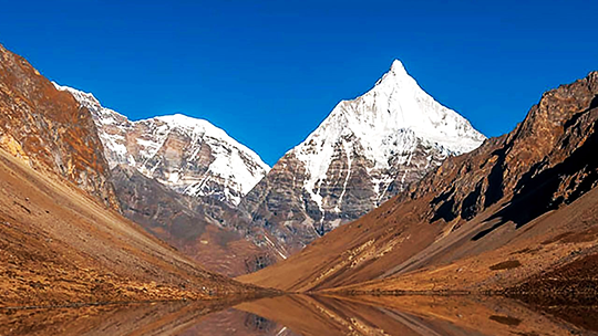
If you did not see Mount Jomolhari the previous evening, you will get a great view in
the morning. The trek continues up the Paro Chhu river valley which widens into patches
of alpine meadow and scanty growths of forest. Cross an army outpost along the way and
enjoy a spectacular view of high mountain ridges and snow-capped peaks. Yaks and the
herder`s homes become a regular feature of the landscape. Passing the beautiful villages
Soe, Takethang and Dangochang is another highlight of today. Reaching Jangothang, one of
the most beautiful campsites of the Himalayas, you will again have a spectacular view of
Mount Jomolhari
Acclimatization
Camp Altitude: 4,080m
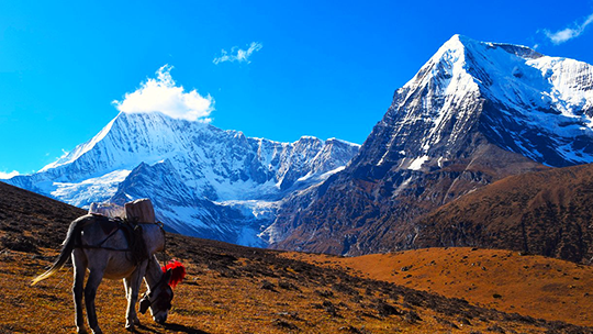
Jangothang is a perfect environment for your acclimatization. There are plenty of
possibilities for day hikes with great views on lakes and snow capped mountains such as
Jomolhari and Jichu Drake. Jichu Drake is also one of those unclimbed mountains. There
are good chances to spot some blue sheep on the upper slopes of the valley. There are
good short hiking trails in three directions. Jumolhari and its subsidiary mountain
chains lies directly west, Jichu Drake to the north and a number of unclimbed peaks to
the east. Nearby there are trout filled lakes. You may also walk towards the glaciers of
Jhomolhari or visit and experience a high altitude village life nearby. Don’t sweat it
too much as you prepare yourself for a tough climb the next day.
Jangothang - Lingshi
Walking Distance: 18km, 6-7 hours, 840m ascent, 870m descent, Camp Altitude:
4,010m
The trail climbs rapidly for about half an hour and then becomes a gradual ascend to the
Nyilila pass at 4,870m. Apart from the beautiful landscape you might see herds of blue
sheep grazing on the slopes of the mountains and spectacular views of Mt. Jomolhari,
Jichu Drake and Tsherimgang. You will pass through yak herder`s tents made from yak
wool. You will also get a view from the top of beautiful Lingzhi Dzong.
Lingshi - Chebisa
Walking Distance: 10km, 5-6 hours,280m ascent,410m descent, Camp Altitude:
3,880m
Today is the shortest walking day, and you can really take it easy. Shortly after
starting you will reach a chorten below Lingshi Dzong. Here, you have the choice of
staying on the main trail or taking a diversion up to the Lingshi Dzong (4,220m), which
sits right atop a ridge. Besides a very special atmosphere of mystic silence Lingshi
Dzong provides a great view over the valley. After Lingshi Dzong you will be passing the
villages of Lingshi and Goyul. In Goyul, the stone houses are clustered together to a
small compact village that is unusual in Bhutan where village houses are normally
scattered. On reaching the campsite at Chebisa with a beautiful waterfall behind the
village, you will have plenty of time to visit the village houses if you feel up to it.
Chebisa - Shomuthang
Walking Distance: 17km, 6-7 hours, 890m ascent, 540m descent, Camp Altitude:
4,220m
You walk through a wide pastureland towards Gobu La (pass)
On the way, you will see a few people herding yaks. There is also a great chance to spot
large herds of blue sheep above the trail. After crossing the Gobu La (4,410m), you
descend to the valley, then climb again a little bit, and descend again to Shakshepasa
(3,980) where a helipad has been established. Climbing from here you will finally reach
the campsite at Shomuthang, above a stream which is a tributary of the Pochu River.
Shomuthang - Robluthang
Walking Distance: 18km, 6-7 hours, 700m ascent, 760m descent, Camp Altitude:
4,160m
Today the walk is a little strenuous; it is advisable to start early. Climb up valley to
view Kang Bum (6,526 m) and some edelweiss. After two hours of climbing you will reach
Jhari La (4,750m), from where you catch the first sight of Sinche La, the pass you will
have to cross the day after. The big snow peak in the north is Gangchhenta 6,840 m,
better known as the Great Tiger Mountain. If weather is clear, Tserim Kang and the top
of Jumolhari will be visible. The camp by the river is called Tsheri Jathang. Herds of
takin, the Bhutanese National Animal, migrate to this valley in summer and remain for
about four months. The valley has been declared a takin sanctuary. Climb up a little bit
and you will reach the campsite at Robluthang in a rocky meadow.
Robluthang - Limithang
Walking Distance: 19km, 6-7 hours, 850m ascent, 870m descent, Camp Altitude:
4,140m
The last and highest pass on the trek, Sinche la(5005m) from Laya onwards - you descend
to a little stone house where a few Laya women - dressed in typical Laya costume with
long pointed bamboo hats on their head - live and offer their weaving products. Right
behind the stone house you will see an impressive terminal moraine and a glacial lake at
the foot of the valley. You can see classic examples of the lateral moraines where the
glacier has pushed rocks up both sides of the valley. Below the moraine, you cross the
Kango Chhu and soon reach the Limithang campsite. The peak of Gangchhenta towers over
the campsite even though it`s quite a distance away.
Limithang - Laya
Walking Distance: 10km, 4-5 hours, 60m ascent, 340m descent, Camp Altitude:
3,840m
Today you walk all the way downhill along a narrow winding river valley. After a long
time, you again trek partly through deep forest. The trail leads you to the west side of
Laya village. From the west of the village you will view Gangchhenta again and catch a
glimpse of Masagang. In the village centre is a community school and a basic health unit
with telephone connection. The campsite is below the school.
Laya (Halt)
Camp altitude: 3840m
Today you can stroll around the village and interact with them. You can experience their
unique culture and traditions. Layaps, the people of laya celebrates a Royal-Highlander
Festival every year in the month of October. You can see more if you coincide to the
festival dates.
Laya - Rhoduphu
Walking Distance: 19km, 6-7 hours, 1030m Ascent, 720m Descent, Camp Altitude:
4,160m
We descend to an army camp and continue following the river till the turn off point to
Rhoduphu.
After lunch the climb continues through rhododendron bushes till you reach the camp at
Roduphu just next to the Rhodu Chhu.
Rhoduphu - Narethang
Walking Distance: 17km, 5-6 hours, 720m Descent, Camp Altitude: 4,900m
After following the river for about half an hour you will have a steady climb to a high
open valley at 4,600m and then further up to Tsomo La (4,900m). Tsomo La offers a superb
view of Lunana, Mount Jomolhari and Jichu Drake, and the Tibetan border. The route then
crosses a flat, barren plateau at about 5,000m. The campsite at Narethang is towered by
the peak of Gangla Karchung (6,395m).
Narethang - Tarina
Walking Distance: 18km, five to six hours, 270m Ascent, 1200m Descent, Camp Altitude:
3,970m
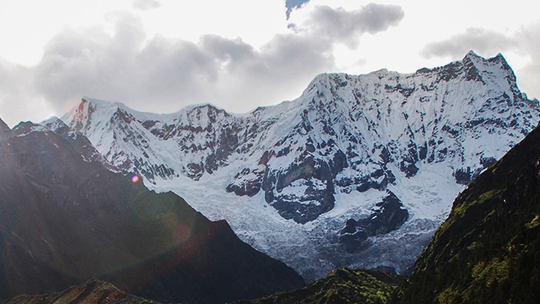
From the camp you will climb for about an hour to Gangla Karchung La (5,120m). The view
from the pass is breathtaking and the whole range of mountains including Jekangphu Gang
(7,100m), Tsenda Kang and Teri Gang (7,300m) can be seen. The pass descends along a
large moraine. Again one has great views: a massive glacier descends from Teri Kang to a
deep turquoise lake at its foot. Up here a glacial lake burst through its dam in the
early 1960s, causing widespread damage and partially destroying Punakha Dzong. Finally,
it is a very long descent through thick rhododendron to Tarina valley, where you will
find several good campsites along the Tang Chhu.
Tarina - Woche
Walking Distance: 17km, 6-7 hours, 275m Ascent, 330m Descent, Camp Altitude:
3,910m
The walk leads down through conifer forests following the upper ridges of the Pho Chhu,
passing some impressive waterfalls. The trail then climbs over a ridge and drops to
Woche, a settlement of a few houses, the first village in the Lunana region.
Woche - Lhedi
Walking Distance: 17km, 6-7 hours, 980m Ascent, 950m Descent, Camp Altitude:
3,700m
The trek starts through juniper and fir forests, and further ahead, through rhododendron
bushes. Climb up to Keche La pass (4,650m) where one can have the great view of
surrounding mountains again. After the pass, descend to the riverside walking through a
village with a stunning view of Table Mountain and others. Follow up the river till
Lhedi Village. Lhedi has a basic health unit, a school and a wireless telephone
connection.
Lhedi - Thanza
Walking Distance: 17km, 5-6 hours, 400m Ascent, Camp Altitude: 4,150m
In clear weather, you will have great views of Table Mountain (7,100m).Around lunchtime
you will pass the small village of Chozo (4,090m) which has a dzong still in use.
Reaching Thanza again you will have a great view of Table Mountain which forms a 3,000m
high wall of snow and ice behind the village. Although there are possibilities to camp
directly at Thanza, most groups prefer to camp in Thoencha.
Thanza (Halt)
Camp Altitude: 4,150m
In Thanza walk around and experience some village life or climb up the ridge for
fascinating views of lakes and mountains. But as it takes time to arrange new yaks (the
yaks from Laya will not go further than Thanza) you might have to spend one day at
Thanza anyway.
Thanza - Danji
Walking Distance: 8km, 3-4 hours, 80m Ascent, Camp Altitude: 4,230m
From Thoencha, the trail climbs up to a large boulder from where you will have excellent
views of Thanza, Toencha and Choso village and the surrounding mountains. After a few
hours of relatively flat and easy walking, you will reach a yak meadow with some yak
herders` huts. An excellent campsite with a great chance to spot some blue sheep on the
hills above. A trail junction near the campsite will give you the choice between the
route up to Gangkhar Puensum base camp, and further on to Bumthang or to Sephu
(Trongsa). Both routes are described in this website.
Danji - Tshochena
Walking Distance: 12km, 5-6 hours, 490m Ascent, 240m Descent, Camp Altitude:
4,970m
Having chosen the route to Sephu, the trek crosses the creek and after a long climb, you
will reach Jaze La (5,150m) with spectacular panoramic mountain views . The path then
descends between snow covered peaks and a couple of small lakes to the campsite near the
shore of Tshochena lake.
Tshochena - Jichu Dramo
Walking Distance: 14km, 4-5 hours, 230m Ascent, 140m Descent, Camp Altitude:
5,050m
You follow the bank of the blue green lake before arriving at a ridge at 5,100m, where
there is another spectacular view in all directions. After going up and down over small
hills to reach a glacial lake, the route descends first before climbing again up the
next pass, the Loju La (5,140m). Finally after crossing a small saddle (5,100m) you will
enter a wide glacial valley from where the trail descends gradually to the campsite at
Jichu Dramo.
Jichu Dramo - Chukarpo
Walking Distance: 18km, 5-6 hours, 320m Ascent, 730m Descent Camp Altitude:
4,600m
Right after leaving the camp you will climb through a moraine to Rinchen Zoe La
(5,320m). Spectacular mountain scenery with Gangkhar Puensum amongst the impressive
mountains is the reward for climbing the highest pass on this trek route. Rinchen Zoe
Peak (5,650) towers above the pass the west. Descending from the pass, the route leads
into a wide valley with several lakes and goes steeply down along a moraine to the
Thamphe Chhu. Here the vegetation begins to thicken again and you will see the first
real trees since Lhedi. After a couple of hours you reach the campsite at Chukarpo.
Chukarpo - Thampe Tsho
Walking Distance: 18km, 5-6 hours, 400m Ascent, 640m Descent Camp Altitude:
4,300m
The descent continues along the river till you reach the yak herder huts at Gala Pang
Chhu (4010m). From here the trail climbs steeply towards Thampe Tsho, a beautiful clear
turquoise lake, with the campsite next to it.
Thampe Tsho - Maurothang
Walking Distance: 14km, 5 hours, 280m Ascent, 1020m Descent, Camp Altitude:
3,610m
From the lake you climb steeply to the last pass on your trek, the Thampe La (4,600m)
with a good chance to spot some blue sheep on the way. Then the path descends to the
sacred lake Om Thso. Passing a waterfall you will reach another, smaller lake 100m below
to descend steeply to the Nikka Chhu. The path finally leads through mixed forest to
large clearing on the banks of the river with a few yak herder huts, Maurothang.
Maurothang - Sephu
Walking Distance: 18km, 5-6 hours, 990m Descent, Altitude 2850m
A well-used trail continues down the west side of nikka-chu for about 30 minitus before
crossing to the east bank into deciduous and bamboo forest. It descents gradually
through forests and pastures,emerging onto a large grassy area over-looking the road and
the sephu village. There are many confusing trail here; look for a large track about 25m
above the river and you will soon pass a large suspension bridge over nikka-chhu,which
you shouldn`t cross. Soon the trail turns into narrow tractor road at Sephu, next to
nikka Chhu Bridge at 2600m, marked by the shops and small restaurant.
Your tour vehicle will wait you here to take you to the hotel.
Gangtey - Punakha
Drive from to punakha is very interesting, you can see wide changes in vegetation as you
are descending towards sub-tropical regions.
Punakha valley was the old capital city of Bhutan and the Punakha Dzong (fortress of
Great Bliss) was built by 1673 by Zhabdrung Ngawang Namgyel (the first spiritual &
political leader of Bhutan) to commemorate the final victory against numerous Tibetan
invasions. Located on a piece of land between two rivers Pho Chhu and Mo Chhu (literally
meaning male and female rivers), the Dzong is massive, huge and magnificent in all its
architectural grandeur. Although ravaged by flood, fire and earthquake many times, the
Dzong was always rebuilt with its original pattern and design.
The Dzong has hosted significant events such as the crowning of the first king of
Bhutan, The Royal Wedding ceremony of the Fifth King Jigme Khesar Namgyel Wangchuck to
Jetsun Pema on 13th October 2011 was conducted in Punakha Dzong and important religious
ceremonies are still held in the Dzong.
The fortress serves as winter home for our central monastic body.
After visiting the Punakha Dzong/Fortress of Great Bliss, drive to the Nunnery and enjoy
the spectacular views of Punakha and Wangdue valleys.
Punakha - Thimphu
After breakfast check out of your hotel and drive to Thimphu capital city. En route stop
over at the Dochulaa Pass (3150 meters) and enjoy the spectacular views of the snow
capped Himalayan Mountains. The 108 small stupas built over a small hill is also a
beautiful sight. The road from the Pass winds down to Thimphu city.
Thimphu is the capital city of Bhutan and is one of the last few capital cities without
traffic lights and the traffic still managed by traffic policemen. Thimphu is the most
populated city in Bhutan with about 150,000 people and is truly a combination of the
ancient and the modern. While strictly maintaining the traditional style of architecture
in modern building, there are also very old temples and numerous monasteries in and
around the city, and few discotheques and Karaoke.
Soak in the panoramic view of the Thimphu valley from the site of the gigantic Lord
Buddha, a 51 meter bronze Shakyamuni Buddha statue gilded in gold.
The beautiful Memorial Chorten/stupa in town is another favorite with the tourists and a
regular site for congregation of devout Buddhists circumambulating the Chorten from dawn
till dusk. The main statue of the Buddha inside the Chorten is said to grant wishes for
the earnest and honest hearted!
If you want to mingle with the Bhutanese people and jostle with local farmers amongst
the aroma of organic fruits and vegetables, the Centenary Farmers Market is the place to
be. Smiling tourists watch in awe as locals bargain with the vendors and you could even
stock up on your organic fruits for the coming days.
Visit the Simply Bhutan Museum which is a living studio showcasing the age old culture
and traditional heritage of Bhutan. Stroll through the market places and the craft
bazaar.
Departure
After breakfast drive to Paro International Airport where your guide and driver will bid
you farewell and hope you had a pleasant holiday and hope to see you in Bhutan again.